Car Navigation Tools
How can drivers' spatial learning skills be compromised?
01
Content guide
GNSS devices and mobile navigation software have become tools that more and more people rely on to get around. At the same time, however, research has found that they may pose a potential threat to a person's own spatial abilities and navigation skills. Passively following mobile navigation tools removes the need for people to rely on their own ability to learn and memorize their geographic environment; how will this affect an individual's own spatial learning ability? This question has not yet been fully revealed.
To answer this question, 24 Beijing cab drivers were recruited for this study, who had consistent usage habits (i.e., using voice-assisted navigation) and significant differences in reliance on mobile navigation tools. By conducting eye-tracking and electroencephalography (EEG) experiments in a laboratory setting, this study assessed the effects of long-term reliance on in-vehicle voice navigation on the spatial learning ability of these navigation experts in terms of behavioral performance, eye-movement indicators, and cognitive load.
02
Research Content
We divided 24 drivers (all male, mean age 51.3 years, mean cab driving hours 8.17 years) into two groups (high dependence group HD, low dependence group LD) based on the subjects' dependence on mobile navigation tools. There were no significant differences (p>.05) between these two groups of subjects in terms of age, length of time in the profession, daily hours of work, educational background, Santa Barbara Sense of Orientation (SBSOD) scale scores, and Spatial Anxiety Scale scores, and they only differed significantly in terms of the number of hours of daily navigation use (p<.001>
As shown in Figure 1, at the beginning of the experiment, we first interviewed the subjects in order to collect their background information and to understand their navigation tool usage habits. In the subsequent experiment, subjects were required to watch two videos of driving scenes of two minutes duration from the DR(eye)VE dataset, filmed in the Italian city of Modena. After each video, subjects were required to complete a spatial knowledge test, including scene recognition, route recognition and sketching, which were used to test subjects' knowledge of landmarks, routes and measurements, respectively. At the end of the experiment, subjects completed two scales.
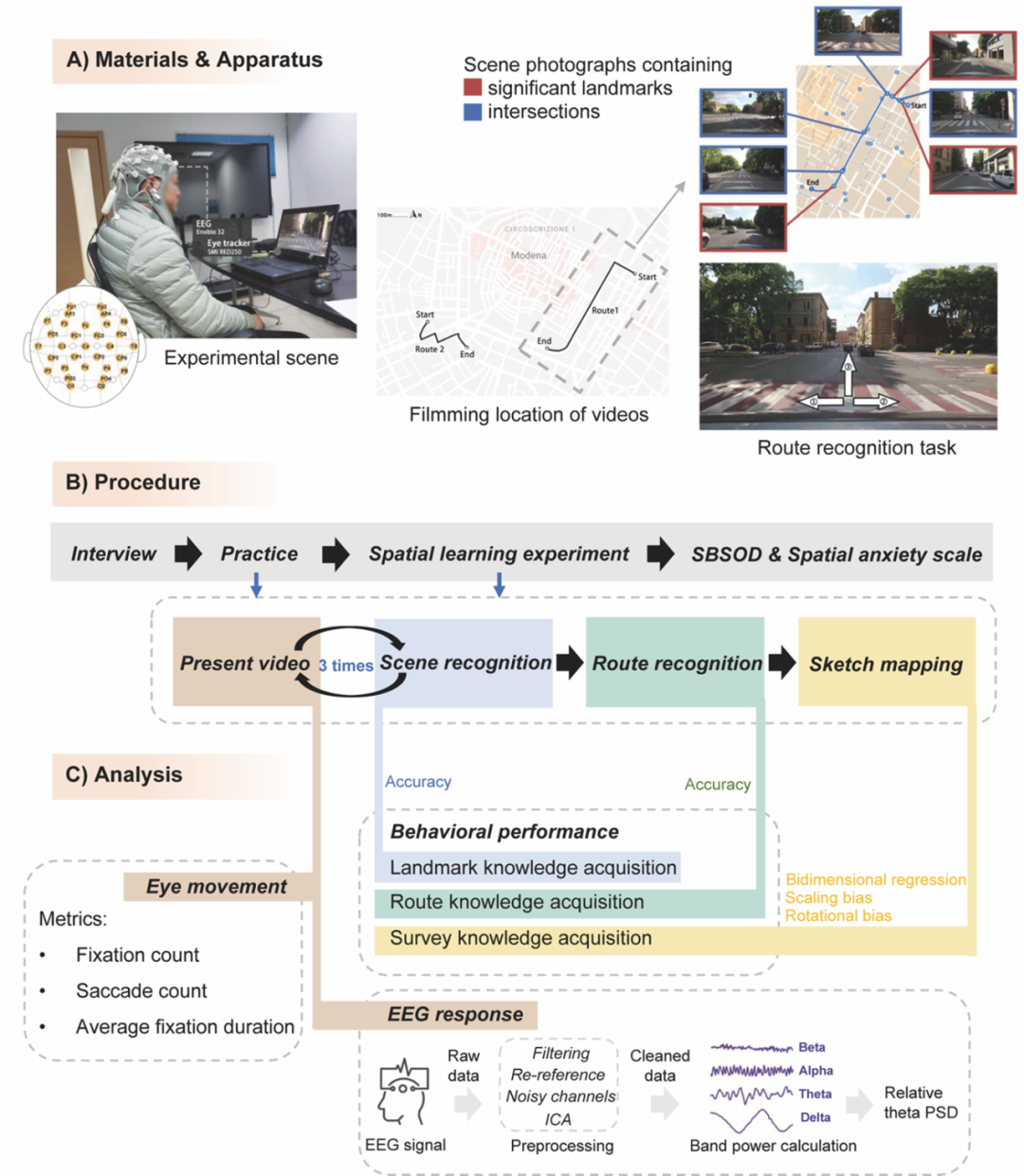

Figure 1. Experimental design, experimental procedure and methods of data analysis
A. Stimulus materials and experimental apparatus used in the experiment
B. Experimental procedures
C. Methods of data analysis for this study
The stimulus material used for the experiment was presented mainly through a 15.6-inch laptop computer with a resolution of 1920*1080 pixels. This computer was connected to both an eye-tracker (SMI RED250) and a 32-conductor EEG device (Enobio 32), which was used to collect eye-movement data and EEG data from the subjects during the experiment.
After the data collection was completed, we calculated the correctness rate for both scene recognition and route recognition tasks.Gardony Map Drawing Analyzer (GMDA) was used to analyze the sketches drawn by the subjects and to output the overall fit r², scaling bias, and rotational bias of the sketches and the real map (Google Map). We analyzed eye-movement and EEG data from subjects during spatial learning by watching videos. For the eye-movement data, we calculated three eye-movement metrics: number of gazes, number of eye hops, and average gaze duration. For the EEG data, we performed power spectral analysis after preprocessing and calculated the relative power spectral density (PSD) of the five frontal electrodes (Fz, F3, F4, AF3, and AF4) in the theta band (4-8 HZ), which was used to reflect the cognitive load of the subjects. Higher PSD in the frontal theta band indicated higher cognitive load of the subjects in accomplishing the task. We then compared the differences exhibited by the two groups of subjects in the above metrics.
03
Study results
We used the Scheirer-Ray-Hare test for the spatial knowledge test results. As shown in Figure 2, the LD group had a significantly higher correct rate of scene recognition than the HD group. In the route recognition task, there was no significant difference between the correct rates of the LD and HD groups. In addition, in the sketch drawing task, the r²There were no significant differences in either the and the rotation bias. However, scaling bias was significantly lower in the LD group than in the HD group, suggesting that subjects in the LD group were better able to estimate inter-landmark distances. Overall, subjects with higher mobile navigation dependence performed worse in acquiring landmark knowledge and measurement knowledge.


Figure 2. Behavioral Performance Statistics for LD and HD Groups
(ns for p>.05, * for p) <.05 p>
A. Correctness of scene recognition tasks
B. Correctness of route identification tasks
C. r² of the sketch made by the subject
D. Scaling deviations of the sketches produced by the subjects
E. Rotational deviation of the sketches produced by the subjects
We performed the between-group independent samples t-test or Mann-Whitney U-test on the eye movement and EEG data of the two routes, respectively. The two groups of subjects did not show significant differences in the eye movement index. Instead, the analysis of the EEG results revealed (Fig. 3) that the cognitive load during spatial learning was significantly higher in the HD group than in the LD group. Another interesting finding is that the cognitive load of the LD group at the intersection was significantly higher compared to that within the road section, which was not significantly different from that of the HD group at the intersection. In contrast, within the roadway section, the LD group showed lower cognitive load, while the HD group still showed high cognitive load. These results can be explained by the fact that the long-term use of the navigation tool increased the difficulty of encoding visuospatial information into memory for the HD group subjects, who thus showed higher cognitive loads when there was no difference in the visual information acquired with the LD group subjects.
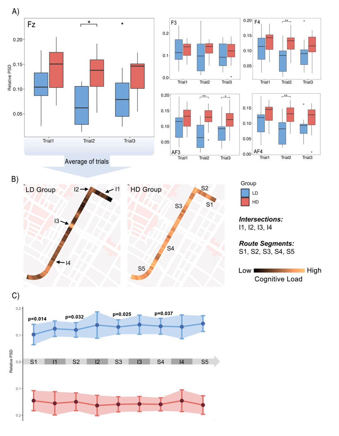

Figure 3. EEG results for Route 1
A. Between-group comparison of theta band relative to PSD for five frontal electrodes (Fz, F3, F4, AF3, and AF4) (* indicates p <.05 p>
B. Spatial distribution of the Fz electrode theta band relative to the PSD
C. Statistical analysis of relative PSD for theta bands within each intersection and roadway segment
04
Summary and Outlook
Our study found that long-term reliance on in-vehicle navigation systems negatively affects drivers' spatial learning ability, making them have higher cognitive loads during encoding and memorization of visual information, and consequently perform worse in acquiring knowledge of landmarks and measurements. This study explores the impact of current and increasingly evolving geographic information technologies on individual cognitive abilities from an interdisciplinary perspective. Our findings are instructive for the design and development of future navigation systems and emphasize the importance of considering human cognitive properties in the development of technology.
05
References
Ying, Q., Dong, W., & Fabrikant, S. I. (2024). How Do In-Car Navigation Aids Impair Expert Navigators' Spatial Learning Ability? Annals of the American Association of Geographers, 1 -22. https://doi.org/10.1080/24694452.2024.2356858
Source: S3-Lab
Content layout: Zhang Yiban

Company Profile
Ltd, invested by Zhongke (Guangdong) Science Group and relying on Guangdong Human Factors Technology Research Institute and Wuhan Human Factors Engineering Technology Research Institute, is a new type of high-tech enterprise based on the direction of psychological human factors, driving human factors, biomechanics, user experience, virtual reality and other directions, integrating production, research and development, sales and technical services, and has been selected as a national high-tech enterprises, science and technology-based Small and Medium-sized Enterprises (SMEs) and Zhongguancun High-tech Enterprises.


Hengzhi Technology independently researches and develops driving human factors system, virtual reality graphical editing software, light environment psychological assessment system, psychological and human factors experimental teaching system, and at the same time as the general agent of Poland Cortivision near infrared, Russia Mitsar electroencephalography and Germany Eyelogic eye-tracking instrument in China, and the general agent of biomechanics and gait analysis scientific research products such as surface electromyography of Italy BTS, and so on. AdHawk Mindlink (Canada), QuaeroSys (Germany), Noldus (Holland), Tobii (Sweden), MindMedia (Holland), Biopac (U.S.A.), ETT (U.S.A.), and other products in the field of olfactory/gustatory stimulation. We have served Tsinghua University, Peking University, Beijing Normal University, Northeast Normal University, Yanshan University, Xi'an University of Architecture and Technology, Northwest Agriculture and Forestry University, Shenzhen University of Technology, Xi'an University of Science and Technology, Shanghai Jiaotong University, Xinjiang Normal University, Qiyuan Laboratory, China Electronics Technology Group 27, China Electronics Technology Group 28, Huawei Technology, InkScan, NetEase, Aerospace Academy II, and so on. Thousands of colleges and universities, research institutes and enterprises and institutions continue to carry out in-depth cooperation in talent cultivation, production and research cooperation, and transformation of achievements.
