
Many beginners, when they first start their research careers, mistakenly refer to "(statistics) correlation"vs."cause and effect"Confusion. For example, in the expert-novice study, both researchers obtained results that professional experience was positively related to task performance, and this effect was significant. At this point, a beginning researcher would assume that it was the knowledge-experience advantage of long-term professional training that caused the expert group to perform significantly better on the task than the novice group. A mature researcher, on the other hand, would consider the results of this data in a number of ways, such as "Is there a trait in the expert that enables him or her to be an expert?" Thus, a mature researcher would be more inclined tointerpret sth. cautiouslyTheir result: "Experts performed better and were more efficient in solving the problem, but the reasons and mechanisms for this need to be further explored". A change in the independent variable cannot be said to cause a change in the dependent variable unless the experimenter has completely manipulated the dependent variable in the experiment.
"Scientists have been studying spatial ability for a long time, and spatial ability is considered to be the third most important cognitive ability of human beings, in addition to verbal ability and mathematical ability. Spatial ability plays an important role in people's daily work and life, for example, daily wayfinding, recognizing new environments, and emergency evacuation all require the use of spatial ability. Quantitative assessment and training of spatial ability has been a topic of concern for us. We think that if we can establish a correlation between visual attention and spatial ability, it will be more objective and practical than the traditional questionnaire measurement. The present study is a small exploration in this direction by our team, and the results open up the possibility of using eye-tracking to measure spatial ability in the future."
-Professor Dong Weihua.
Beijing Normal University
School of Geographical Sciences
Original link: https://www.mdpi.com/2220-9964/7/9/337
Rationale for recommending the study:
-
This study explored the spatial competence of geography majors and non-geography majors'cognitive processDifference;
-
Cautiously explains the importance of a system based onsubject independent variableThe experimental results of the
-
Use a clearOne-factor inter-subjectExperimental design that focuses on answering the research question posed;
-
Uses three programs based on theGaze and Eye Jumpsof indicators that reveal spatial task cognitive processes.
You will be able to learn about it through this article:
-
spatialindividual differencesResearch;
-
Eye tracking tools in the field of spatial cognition;
-
PromotionGeography teachingof improvement possible.
spatial abilityThe concept originated inTolman, defined as the ability to perceive, learn, memorize, reason, and communicate spatial information. Training can improve spatial ability, but there is still a gap in research on the differences in cognitive processes of spatial tasks between geographers and non-geographers. As the foundation of spatial thinking, spatial competence is essential for individuals in theSTEM(Science, Technology, Engineering, Mathematics) The development of the field is very important. Spatial abilities are categorized intoThree subcomponents: The
-
spatial orientation(Spatial Localization): Locate yourself according to a local, relevant or global frame of reference;
-
spatial orientation(Spatial Orientation): refers to determining the direction in which one is facing in a given frame of reference;
-
Spatial visualization capabilities(Spatial Visualization Capabilities: The ability to rotate, twist, or transform a two- or three-dimensional spatial object through imagination.
It has been confirmed in previous studies that there is a difference in spatial ability among individuals with different professional backgrounds. And this difference is moderated by gender differences, as shown by the fact that women with a professional background in geography have stronger spatial abilities than men with the same background. However, these studies have generally focused onMission performanceand the lack of space missioncognitive processstudy.
In order to further explore the cognitive processes involved in spatial ability and its related tasks, this study focuses on two research questions and the corresponding research hypotheses:
-
Research Question 1: Are individuals with a geography background more spatially competent?
-
Research Hypothesis 1: Individuals trained in geography have greater spatial competence as evidenced by higher rates of correctness and lower response times on the four experimental tasks.
-
Research Question 2: Is this facilitation effect reflected in visual cognitive processes?
-
Research Hypothesis 2: Individuals trained in geography specialization have better visual attention strategies in spatial tasks, as evidenced by less investment of visual cognitive resources and more focused visual attention patterns.
Using aone-way binary level (i.e. two-way street)Between-subjects experimental design.
The independent variable was the professional background of the subjects. There were two levels, geography majors and non-geography majors.
Five dependent variables were used to assess subjects' task performance and cognitive processes: The

4.1 Experimental materials
The experiment contains4resembletotal12The spatial ability test questions, all of which have been carefully selected based on prior research.4An overview of the individual types of topics is provided below:
-
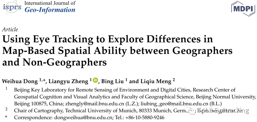
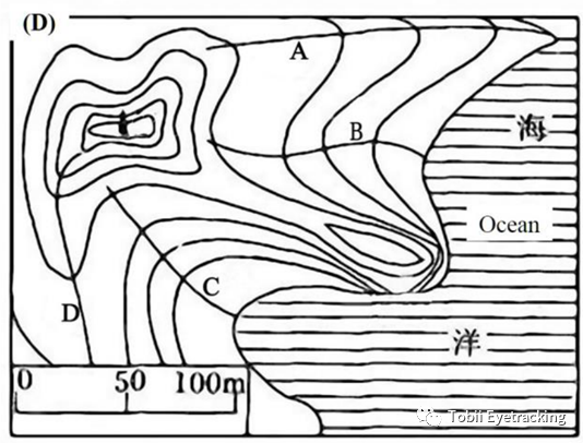
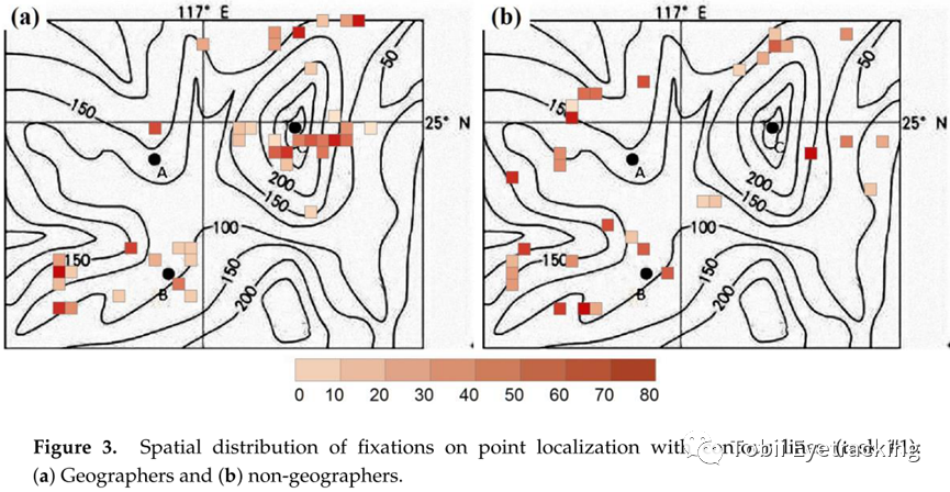
Point localization with contour lines finds the highest elevation among several points on a contour map;
![]()
-
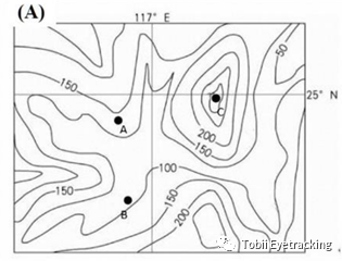
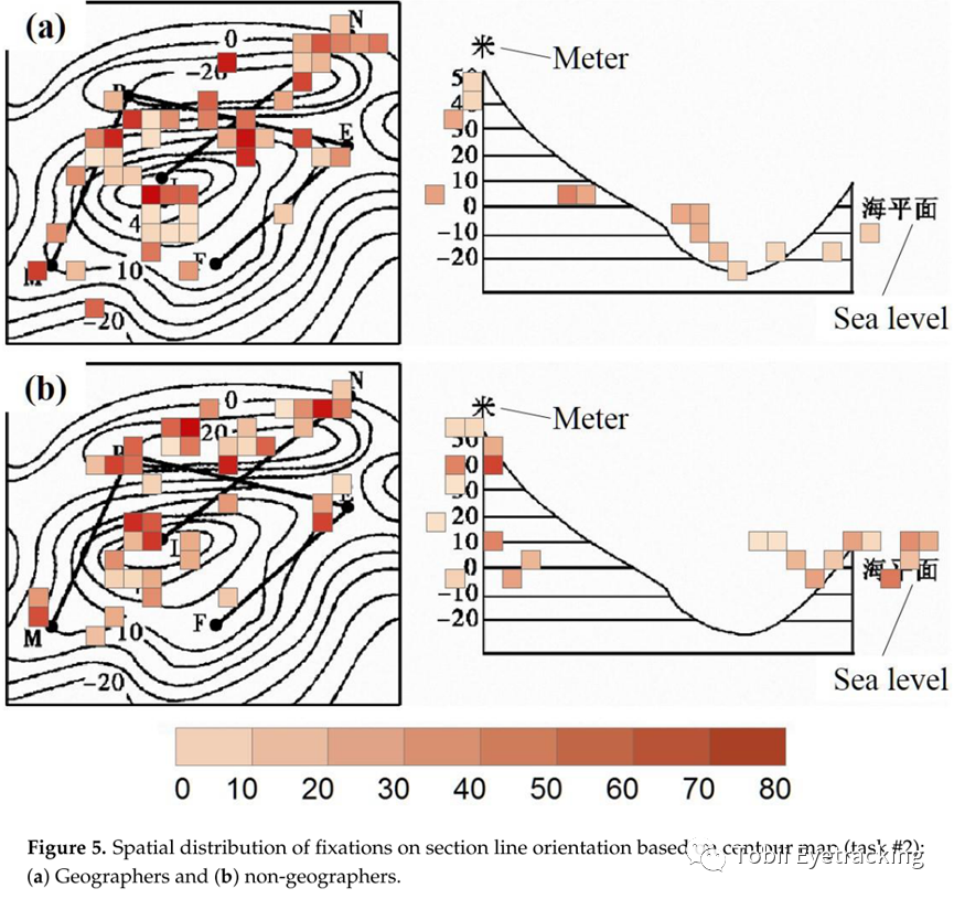
Section line orientation based on contour map matches contour maps and section line maps of the same terrain;
![]()
-
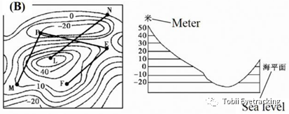
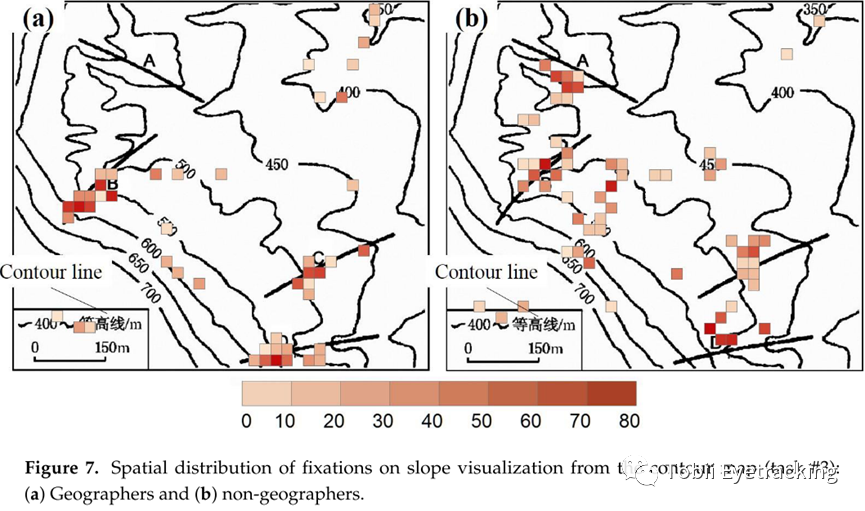
Slope visualization from contour map (Slope visualization from contour map), pointing out the line with the largest slope in the contour map;
![]()
-
Terrain determination by visualizing contour maps describes the topography of an area labeled on a contour map to the primary test taker.
The topics were developed and selected according to the following four principles:
-
Topics for non-geography majorsCan't be too hard.;;
-
Maps shall be focused.No irrelevant information;;
-
Problems solvedNo a priori knowledge required;;
-
All necessary information isBeing able to get from the map.
4.2 Experimental Procedures
First, the definitions of Mountain Peaks and Mountain Valleys were first explained to the non-geography majors. Then a background information survey was done, including information such as gender and frequency of map use. A pre-experiment was then conducted in which subjects were shown maps unrelated to the formal experiment and asked questions, during which they could ask any questions. The formal experiment was then started while eye movement behavior was recorded.
4.3 Experimental subjects
Thirty-two undergraduate and graduate students from a university in Beijing participated in the experiment, 16 of whom were geography majors. The geography majors had taken courses in surveying and mapping, geologic geomorphology, geographic information systems, and geographic field practice. The non-geography majors had taken science in high school and had not received any courses or training in the field of geography. All subjects were native Chinese speakers with good visual acuity or corrected vision..
4.4 Experimental apparatus
The Tobii T120 eye-tracking device was used, the sampling rate was 60hz, the stimulus material was presented on a 17-inch monitor with a resolution of 1280x1024pix, the light environment of the experimental environment was controllable, and the effective sampling ratio of the eye-tracking data (Gaze Sample) was greater than 80%, and the eye-tracking experiments lasted 20-30min..
(Fusion motion picture)
5.1 Results
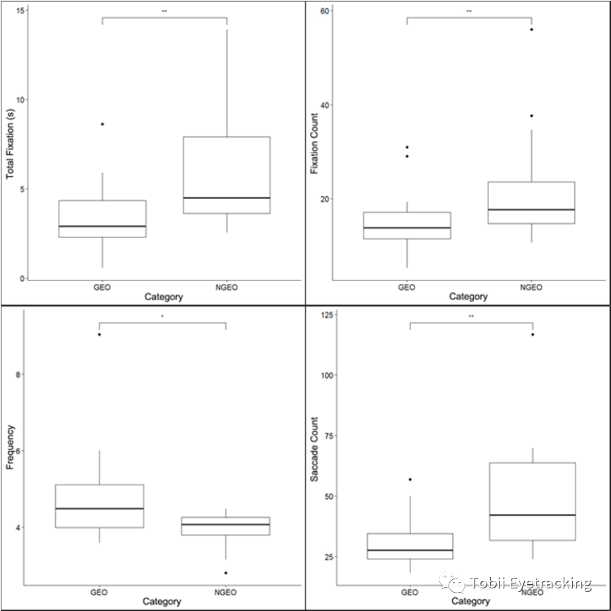
The results of Task 1 showed thatGeography studentsThe duration of the task was significantly shorter thanNon-geography majors(hereinafter referred to asProfessional and non-professional groups); there was no significant difference in gaze duration; however, the frequency of gaze was significantly greater in the professional group than in the non-professional group; and the number of eye jumps was significantly less in the professional group than in the non-professional group.
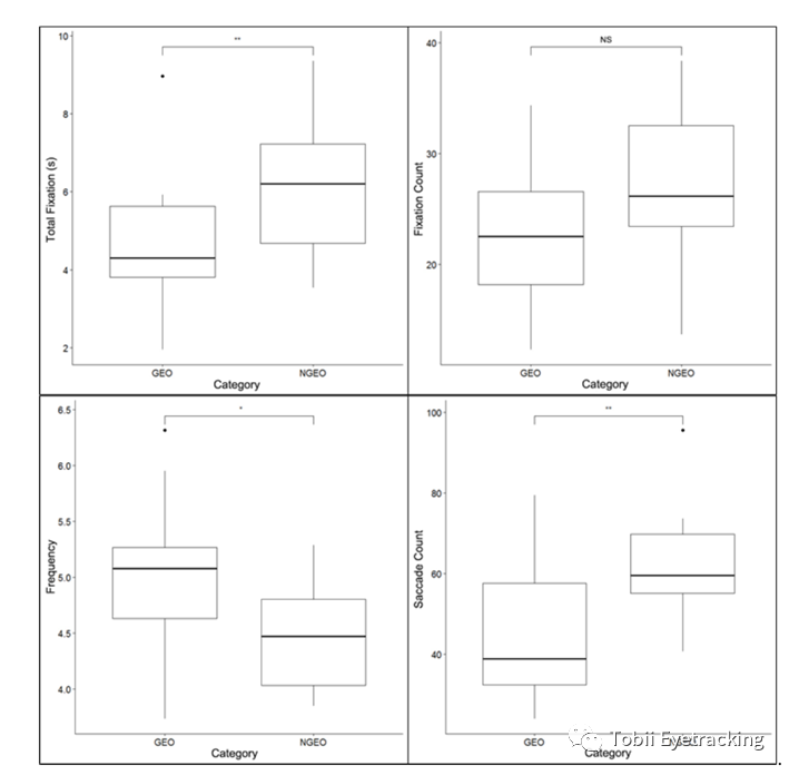
The spatial distribution of gaze shows that geography majors' gaze is more regular and focused around key information. Non-specialized students' gaze was more dispersed and the order of gaze was more chaotic and disorganized, containing some irrelevant information.
In Task 2, the duration of the task was shorter for the professional group than for the non-geography students; the number of gaze and eye jumps was lower for the professional group than for the non-geography students; and the frequency of gaze was significantly higher for the professional group than for the non-geography students.
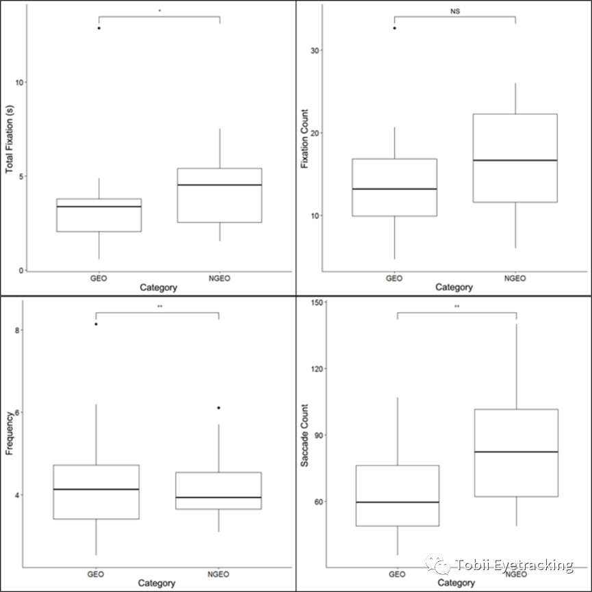
From the hotspot map, the professional group focused their gaze more on elevation and contour information, while the non-professional group's gaze was more dispersed. The specialized group also had a shorter number of gaze transitions between the two maps, and a shorter number and duration of gaze on the contour lines.
In Task 3, the specialized group had less time on task, fewer gaze counts and fewer eye dips than the non-specialized group. However, the frequency of gaze was higher than that of the non-professional group.
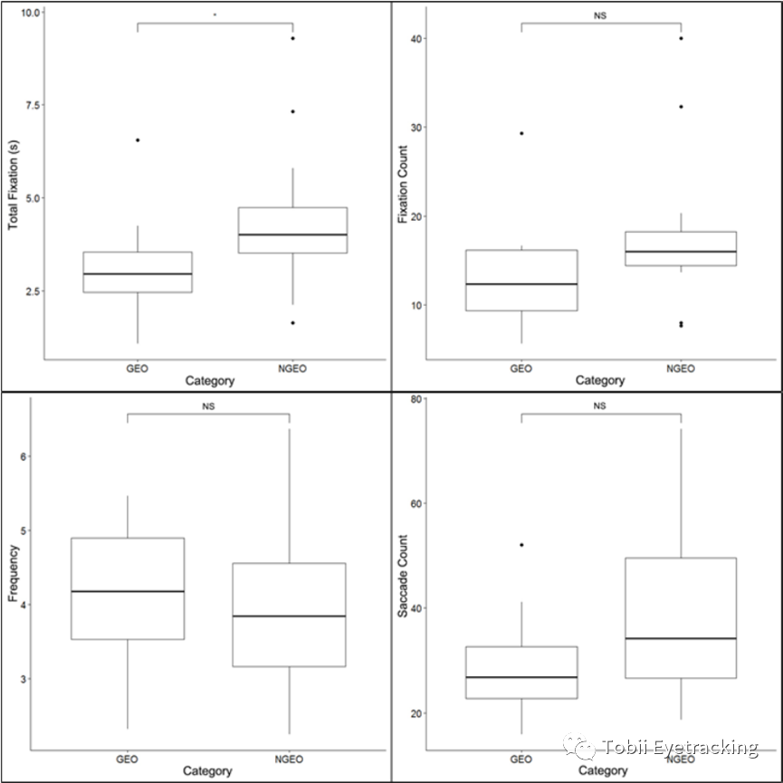
The hotspot map shows that the professional group showed greater efficiency in reading the map, with a relatively uniform order of gaze.
In Task 4, the professional group had a lower time on task, lower number of gaze and eye jumps, and a higher frequency of gaze than the non-professional group.
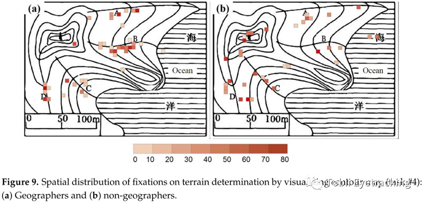
Looking at the hotspot map, the specialized group focuses more on problem-related areas. When reading the maps, there is a similarity in the reading pattern of the specialized group, while the non-specialized group scans the whole map.
5.2 Discussion and conclusions
Viewed in the context of the four mandates.Shorter answer times for specialized groups, , ,Higher accuracyandBetter at extracting and understanding.. Specialized groups paid more attention to key information when scanning topographic maps, showed more uniform regularity in searching for informationLess eye-popping.
The professional group was more efficient in extracting and comprehending key information and also showed more focused attention on key areas and fewer distractions. In the processing and sequencing of dynamic stimuli, the professional group focused more on task-relevant regions. The specialized group could obtain more information from a given map in less time. Whereas, the non-specialized group focused on both key information and irrelevant areas such as scale and redundant contours.
5.3 Conclusions of the study
Compared to non-geography studentsGeography majors spend less time reading maps, are more accurate, pay more attention to key information points, note fewer numbers, and extract information more quickly.. These findings suggest that geography majors are more effective and efficient in solving spatial problems. However.It's hard to be sure.Whether this advantage is due to innate spatial ability (determined by genetic or gender factors) or acquired geographic training.
Specialist in traditional spatial competenciesIn novice studies, the researcher is able to detect where and to what extent the expert is superior to the novice. However, it was not possible to reach"get to know the reason why"understanding, this is because traditional behavioral research focuses on rational inferences and explanations of behavioral outcomes and tends to ignore cognitive processes. As in the eye-tracking workshop at the National Academic Conference on Psychology, theTobii ABscience writerDr. Ieva Miseviciuteonce discussed:"InAmong behavioral responses such as keystroke response, mouse tracking, and verbal reports, cognitive processes are difficult to track, and only the final behavioral response is recorded. Whereas eye-tracking can consistently reveal continuous cognitive processes."
Through the application of eye-tracking technology, Dong et al. not only explored the task performance of geography majors and non-geography majors, but also from the perspective of cognitive processes, thisMechanisms and principles of difference formation. Process data such as eye tracking can bring new perspectives to researchers. And these behavioral process data, when distilled and summarized, can also shed light on professional teaching, for example, when reading a map ofBased on the expert's eye movement trajectory, teachers can guide students to focus on some areas and ignore unimportant areas to conserve cognitive resources.
In this issue of [Essay Intensive Reading], we introduce you to the spatial cognition research of Mr. Dong Weihua's team at Beijing Normal University Using Eye Tracking to Explore Differences in Map-Based Spatial Ability between Geographers and Non-Geographers . In a theoretical sense, the study provides a new, process-oriented research perspective for the study of ability differences. Practically, the study helps to further refine the components of spatial competence from the perspective of cognitive processes, thus providing insights for academic and professional training..

This Saturday morning, April 1, 2023, from 10:00-12:00, we will be hosting the authors of this paper intensive reading from theBeijing Normal UniversityofProf. Wei-Hua DongSynergyHunan Normal UniversityofAssociate Professor Liao HuabehaviorWe're bringing in [Eye tracking techniques in geospatial cognition research]Topics.
Prof. Dong will give us a presentation based on[【Principles and Methods of Spatial Cognition Eye Movement Experiments in Cartography]Keynote report on the topic;Associate Professor Liao Huacommander-in-chief (military)To share with us relevant practical experience in the field of geospatial cognitive eye movement research:[【A practical example of map eye-tracking research]We welcome all interested parties to register for this online event by contacting the QR code below. If you are interested in this online event, please contact the QR code below to register.

References
-
Dong W, Zheng L, Liu B, Meng L. Using Eye Tracking to Explore Differences in Map-Based Spatial Ability between Geographers and Non-Geographers. ISPRS International Journal of Geo-Information. 2018; 7(9):337.
a thank-you note
Thanks to Mr. Dong Weihua of Beijing Normal University for authorizing us to report and interpret this article, and thanks to Mr. Dong and Mr. Liao Hua of Hunan Normal University for their great support in writing this article..


