010-53352947


Research Background


Geospatial cognition is the process by which humans perceive geographic information, maintain spatial representations in memory, and manipulate these representations to guide behavior. Studying geospatial cognition helps geographic information scientists understand the impact of the environment on human psychology and develop more personalized geovisualization methods. In recent years, as geospatial applications such as smart maps, autonomous driving, and intelligent remote sensing interpretation have flourished, the demand for "human-centered" research has increased, prompting researchers to gain a deeper understanding of spatial cognitive processes at the neural level. Past studies have relied on questionnaires and behavioral measurements, which capture subjective experiences and observable behaviors, but do not directly measure the neural mechanisms that drive these behaviors.

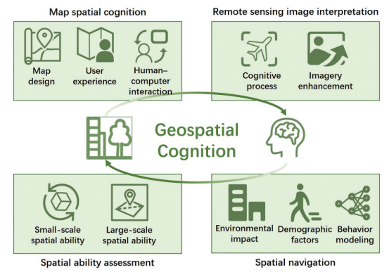
Therefore, this paper proposes a research framework that combines psychology and neuroscience with the aim of unraveling these mechanisms and exploring the application of the framework to four key areas: map spatial cognition, remote sensing image interpretation, spatial navigation, and spatial ability assessment.

01

Research framework


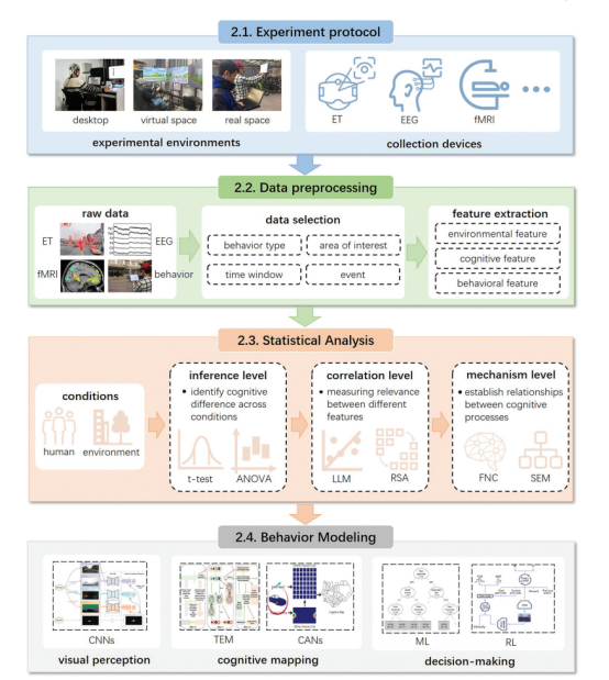
The new framework for geospatial cognition research integrates psychological and neuroscientific approaches and covers four key steps: experimental design, data preprocessing, statistical analysis, and behavioral modeling.

During the experimental design phase, the researcher ensures a high degree of control of the experimental paradigm by simulating spatial tasks in natural environments and eliminating variables that are not relevant to the study. Flat display devices (e.g., computers and tablets) are commonly used in experiments; virtual display devices such as head-mounted displays and augmented reality (AR) glasses are commonly used in driving simulation studies. Non-invasive devices (e.g., eye tracking, electroencephalography, and functional magnetic resonance imaging) are used during the signal acquisition phase to record participants' eye movements and brain activity patterns to reveal complex spatial cognitive processes.

 In the data preprocessing stage, the researcher processed the signals and extracted features related to cognitive processes through algorithms such as independent component analysis, spatial filtering and motion correction. Table 1 lists common cognitive features. In addition, behavioral features can be incorporated to aid in the analysis.

In the statistical analysis stage, the researcher establishes statistical relationships between cognitive traits and the environment through three levels of analysis: inferential, correlational, and functional.

In the behavioral modeling phase, researchers use artificial intelligence models such as convolutional neural networks to simulate human visual perception, cognitive mapping, and decision-making processes to better understand the mechanisms of human-environment interaction.

02

Research applications


In map spatial cognition, the study analyzes the impact of map design elements (e.g., colors, symbols) on user cognition through eye tracking and EEG techniques, and finds that optimizing map symbols and design can significantly improve navigation efficiency and user experience. In remote sensing image interpretation, eye tracking and EEG are used to analyze the visual search behavior and cognitive potential of experts, and to improve the detection of low-contrast targets through artificial intelligence techniques. In the field of spatial navigation, studies have shown that environmental factors (e.g., landmark saliency, road network patterns) and individual differences (e.g., gender, experience) have a significant impact on navigation behavior, and AI techniques can be used to simulate human visual attention and navigation decisions. Finally, in terms of spatial ability assessment, by combining behavioral tests and neuroimaging techniques, it was found that geography education can significantly improve students' spatial ability, which is closely related to the optimization of brain networks. These application areas demonstrate the broad value and potential of the framework in geospatial cognition research.

03

Challenges and objectives


The challenges of applying methodologies from psychology and neuroscience to geospatial cognitive research are shown in Table 2.

In terms of map spatial cognition, the study assesses the impact of visual elements (e.g., colors, symbols, etc.) in map design on user cognition through eye-tracking and other techniques, and explores the differences in map use among users of different genders, ages and occupations. In addition, the combination of human-computer interaction and eye-tracking technology provides new ways to improve the map reading experience.

The Remote Sensing Image Interpretation section focuses on how experts can use geographic knowledge for image interpretation, and extract cognitive features and optimize image interpretation algorithms through techniques such as ET and EEG.

Spatial navigation studies have explored the effects of environmental factors (e.g., landmarks, road networks) on human cognition and different spatial behaviors due to demographic factors. It also reveals the neural mechanisms involved in the navigation process through techniques such as EEG and fMRI.

The Spatial Competence Assessment section assesses differences in individual performance on small- and large-scale spatial tasks through behavioral testing and brain network analysis, and explores the role of geography education in enhancing spatial competence.

summarize

With the rapid development of technologies such as smart maps, automatic driving and intelligent remote sensing interpretation, geospatial cognition research has become increasingly important. In this paper, we propose a research framework that combines psychology and neuroscience to delve into the neural mechanisms of geospatial cognition through eye tracking, electroencephalography, functional magnetic resonance imaging, and other techniques. The framework not only contributes to the understanding of environmental influences on human psychology, but also supports the development of more personalized geovisualization tools. However, challenges remain. The end of the paper points out the problems and future directions of the study in terms of signal acquisition, experimental design, data fusion, and artificial intelligence application, aiming to provide a reference for subsequent geospatial cognition research.


Original Message


Hei, Q., Yang, T., Dong, W., He, B., & Han, D. (2025). Leveraging psychology and neuroscience for geospatial cognition research. Annals of GIS, 1-13. https://doi.org/10.1080/ 19475683.2025.2451228

Company Profile

Ltd., invested by Zhongke (Guangdong) Science Group Co., Ltd. and relying on Guangdong Human Factors Technology Research Institute and Wuhan Human Factors Engineering Technology Research Institute, is a new type of scientific and technological enterprise based on the direction of psychological cognition, brain science, driving human factors, virtual reality, biomechanics, neuromodulation and other aspects of the collection of research and development, production, sales, and technical services, with a number of invention patents, software and registered trademarks. We have many invention patents, software copyrights and registered trademarks. The company has been selected as a national high-tech enterprise, science and technology-based small and medium-sized enterprise, innovative small and medium-sized enterprise, Zhongguancun high-tech enterprise, and participated in the preparation of many national standards and group standards.
Hengzheng Technology has been serving universities and research institutes for a long time, taking the responsibility of doing its part in China's scientific research and maintaining a good cooperative relationship with the Chinese Psychological Association, the Architectural Society of China, the Chinese Society of Ergonomics, the Chinese Society of Technological Economics, the Chinese Society of Management Science and Engineering, and the Chinese Society of Automotive Engineering and other societies! At present, it has become the deputy secretary-general unit of Engineering Construction Management Committee of China Society for Technical Economics, and the deputy secretary-general unit of Ergonomics Committee of China Society for Human Ergonomics! In order to promote the development of the industry, Hengzhi Technology organizes, undertakes, co-sponsors and supports more than 40 conferences every year.


Scan the code to follow us


share (joys, benefits, privileges etc) with others
favorite
look at
kudos

en_USEnglish